- New eBook additions
- All About Education
- Cozy ebooks for Fall
- Made in West Virginia
- A Shore Thing
- First in the series
- Strange New Worlds
- Worlds of Fantasy
- Most popular
- Available now
- Try something different
- Just Plain Good
- See all ebooks collections
1 of 1 copy available
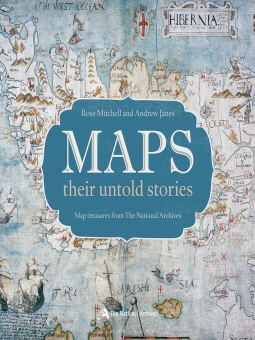
The text explores who the mapmakers were, the purposes for which the maps were made, and what it tells us about the politics of the time. Great images are accompanied by compelling stories. Featured is a woodcut map of 16th Century London, a map of where the bombs fell during the Second World War, and a map the first American settlers' drew when they were attempting to establish a new empire on Roanoke Island, off the coast of what is now North Carolina.
Richly illustrated with large scale reproductions of the maps, the book also includes some of the more amusing or esoteric maps from the National Archives, such as the map of the Great Exhibition in 1851 that was presented on a lady's glove, a London Underground map in the form of a cucumber, and a Treasure Island map used to advertise National Savings.
This is a fascinating and unusual journey through the world of maps and mapmakers.
-
Creators
-
Publisher
-
Release date
September 11, 2014 -
Formats
-
Kindle Book
-
OverDrive Read
- ISBN: 9781408189696
- File size: 228137 KB
-
EPUB ebook
- ISBN: 9781408189696
- File size: 228137 KB
-
-
Languages
- English
-
Reviews
-

October 15, 2014
This is the third source published in 2014 that focuses on maps through the ages (the others being The Oxford Map Companion and Great Maps). This volume is unique in that the selected examples come from the National Archives of the United Kingdom. The quirky and interesting maps here include one of a rabbit warren drawn in 1580, a map of Fort Niagara in 1759, a chart of Vesuvius and the Bay of Naples in 1678, and a sketch of the Auschwitz death camp in 1942. Similar to the aforementioned sources, this volume uses double-page spreads for the text and accompanying maps, with quality reproduction on heavy paper. This is another option for a book of historical maps, but only major cartography collections will need all three.(Reprinted with permission of Booklist, copyright 2014, American Library Association.)
-